effearthradius
Description
Re = effearthradius(atmos)Re of a spherical earth where
atmos is an atmosphere of a
radarScenario
object. The effective radius is computed using the atmosphere and
its associated properties. This syntax generally applies for altitudes less than 2 km. For
more information about the computation, see Effective Earth Radius from Refractivity Gradient.
[
also outputs the effective earth radius factor, Re,k] = effearthradius(___)k. Use this option with
any of the syntaxes described above. See Effective Earth Radius.
Examples
Define an atmosphere in a radar scenario using an effective Earth radius model with a default 4/3 Earth radius.
scenario = radarScenario('IsEarthCentered',true);
atmos = atmosphere(scenario,'EffectiveEarth');
Re = effearthradius(atmos)
Re =
8.4774e+06
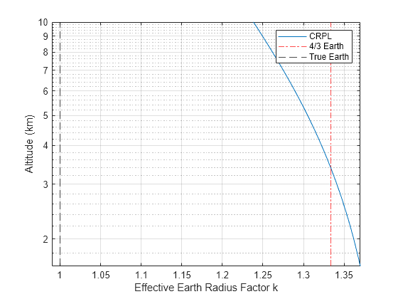
Compare the effective Earth factors calculated from the CRPL and 4/3 Earth models. Assume the slant range is 100 km, the antenna heights range from 1 to 10 km, and the target altitude is at the surface.
 SR = 100e3;
 ha = linspace(1,10,50).*1e3;
 ht = 0;
Create a radar scenario and a CRPL atmosphere.
scenario = radarScenario('IsEarthCentered',true);
atmos = atmosphere(scenario,'CRPL');
[~,kCRPL] = effearthradius(atmos,SR,ha,ht);
Plot the computed k-factor and a vertical 4/3 line.
semilogy(kCRPL,ha*1e-3)
hold on
xline(4/3,'-.r')
xline(1,'--k')
xlim([0.99 1.37])
grid on
legend('CRPL','4/3 Earth','True Earth')
xlabel('Effective Earth Radius Factor k')
ylabel('Altitude (km)')
hold off
Input Arguments
Output Arguments
More About
References
[1] Doerry, Armin. W. "Earth Curvature and Atmospheric Refraction Effects on Radar Signal Propagation", Sandia National Laboratories, SAND2012-10690, January 2013.
[2] Long, Maurice W. Radar Reflectivity of Land and Sea, 2nd Ed. Artech House, 2001.
[3] Mahafza, Bassem R. Radar Signal Analysis and Processing Using MATLAB, CRC Press, 2009.
[4] Skolnik, Merrill I. Introduction to Radar Systems, Third edition, McGraw-Hill, 2001.
[5] Ward, James. "Space-Time Adaptive Processing for Airborne Radar", Lincoln Lab Technical Report, 1994.
Version History
Introduced in R2022b