pcviewer
Description
Use the pcviewer object to view and inspect large 3-D point
clouds. You can interact with the point cloud, and set camera and viewer properties. Point
cloud interactions include navigating through the point cloud, modifying the size of points or
enlarging their display, and selecting viewing planes. Camera and viewer properties enable you
to select between first-person and orbital camera navigation, select a perspective or
orthographic camera projection, and set camera location properties.
Creation
Syntax
Description
viewer = pcviewer( creates a point
cloud viewer that visualizes points stored in the object specified by
ptCloud)ptCloud. You can access and modify point cloud viewer properties
using the returned pcviewer object viewer.
viewer = pcviewer( visualizes
points stored in the file specified by filename)filename.
filename must be a PLY, PCD, LAS, or LAZ file type. LAS/LAZ files
support requires the Lidar Toolbox™.
viewer = pcviewer(___,
specifies the colors with which to visualize the points of the point cloud, in addition to
any combination of input arguments from previous syntaxes.color)
viewer = pcviewer(___,
specifies options using one or more name-value arguments. For example,
Name=Value)VerticalAxis="XUp" sets the x-axis as the vertical
axis in the viewer, with up as positive.
Input Arguments
Point cloud, specified as a pointCloud object. The viewer uses the Location
property of the input point cloud object to render the position of the points. By
default, the viewer sets the colors of the points from the Color
property of the input pointCloud object or by applying a colormap
based on the z-values from the Location property
of the object.
Filename, specified as a string scalar or a character vector. The file must be provided as a PLY, PCD, LAS, or LAZ file type. formatted file.
LAS/LAZ files support requires the Lidar Toolbox. LAZ files returned by the lasFileWriter (Lidar Toolbox) object, which facilitates writing point cloud data to
LAS/LAZ formats, are optimized for display. The viewer is also optimized for LAZ files
stored in the Cloud Optimized Point Cloud (COPC) format. For more details, see the
COPC website.
Color for points in the point cloud, specified as an RGB triplet, an
M-by-3 matrix, or an
M-by-N-by-3 array for an organized point cloud,
a short color name, a long color name, array of color names, or a cell array of color
names. The color input sets the Color
property. For details on color values, see Color Values table.
If the data type of the point cloud
Locationproperty issingleordouble, eachcolorRGB value must be in the range [0, 1].If the data type of the point cloud
Locationproperty isuint8, eachcolorRGB value must be in the range [0, 255].The
Colorproperty of thepcviewerobject stores thecolorvalue as an RGB triplet, an M-by-3 matrix, or an M-by-N-by-3 array. If you specify the color one or more color names, the function converts them to their corresponding RGB triplets.
| Color | Format | Example |
|---|---|---|
| Specify one color for all points | Short or long color name. |
|
1-by-3 vector (RGB triplet). |
| |
| Specify a color for each point | String array, or cell array of character vectors. |
|
M-by-3 matrix for an unorganized point cloud, in which each row is an RGB triplet. M is the number of rows in the unorganized point cloud. | 255 0 0 255 0 0 0 255 255  | |
M-by-N-by-3 array for an organized point cloud, in which each page specifies the red, green, or blue value for the corresponding point in the point cloud. M-by-N is the size of the organized point cloud. |
|
Name-Value Arguments
Specify optional pairs of arguments as
Name1=Value1,...,NameN=ValueN, where Name is
the argument name and Value is the corresponding value.
Name-value arguments must appear after other arguments, but the order of the
pairs does not matter.
Example: viewer = pcviewer(ptCloud,ViewPlane="XY")" visualizes the
point cloud from the xy-plane.
Camera projection for 3-D views, specified as one of these values:
"perspective"— Projects the viewing volume as the frustum of a pyramid (a pyramid whose apex has been cut off parallel to the base). Objects further from the camera appear smaller. Distance causes foreshortening, which enables you to perceive the depth of 3-D objects. This projection type is useful when you want to display realistic views of real objects. Perspective projection does not preserve the relative dimensions of objects. Instead, it displays a distant line segment smaller than a nearer line segment of the same length. Lines that are parallel in the data might not appear parallel in the scene."orthographic"— This projection type maintains the correct relative dimensions of graphics objects regarding the distance of a given point from the viewer. Relative distance from the camera does not affect the size of objects. Lines that are parallel in the data parallel appear parallel on the screen. This projection type is useful when it is important to maintain the actual size of objects and the angles between objects.
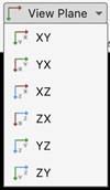
Axes plane to display of point cloud, specified as "auto",
"XY", "YX", "XZ",
"ZX", "YZ", or
"ZY".
Vertical axis and direction, specified as "ZUp",
"ZDown", "XUp", "XDown",
"YUp", or "YDown". This argument sets the
selected axis of the point cloud as the vertical axis, positive in the specified
direction..
Source of colormap data to use for the viewer, specified as one of:
"X"— Viewer maps the x-coordinates in theLocationproperty of the input point cloud."Y"— Viewer maps the y-coordinates in theLocationproperty of the input point cloud."Z"— Viewer maps the z-coordinates in theLocationproperty of the input point cloud."Intensity"— Viewer maps theIntensityproperty of the input point cloud."Color"— Viewer maps theColorproperty of the input point cloud."Row"— Viewer maps the row values of an organized point cloud."Column"— Viewer maps the column values of an organized point cloud."auto""— If theColorproperty of the input point cloud is available, the object uses those color values. Otherwise, the object assigns the colormap based on the z-coordinates in theLocationproperty of the input point cloud.
If you provided the color input, the
ColorSource name-value argument is not used.
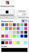
Viewer background color, specified as an RGB triplet, hexadecimal color code, or a character vector for a short or long color name. For details on color values, see the Color Value table.
Size of point cloud points, specified as a positive scalar, in pixels.
State of axes visibility, specified as "on" or
"off", or as a numeric or logical 0
(false) or 1 (true). A
value of "on" is equivalent to true, and
"off" is equivalent to false. Thus, you can
use the value of this property as a logical value. The value is stored as an on/off
logical value of type matlab.lang.OnOffSwitchState.
"on"— Display the axes and its children."off"— Hide the axes without deleting it. You still can access the properties of an invisible axes object. (Child objects such as lines remain visible.)
Logical to enable point cloud optimization for display performance, specified as
1 (true) or 0
(false). When you set this argument to true,
point clouds with more than 10 million points are converted into an octree
structure. This structure renders a subset of points visible from the current
viewpoint and adapts as the viewpoint changes. Enabling this optimization enhances
interaction performance.
When you set this argument to false, all points are
displayed. Displaying all points can decrease interaction performance, depending on
your graphics hardware. For more details about graphics rendering in MATLAB®, see System Requirements for Graphics
Creating an octree structure requires the Lidar Toolbox. If the Lidar Toolbox is not available, all points will be displayed, which can decrease interaction performance.
Properties
Sizes of points, specified as a positive scalar, in pixels.
Point display magnification, specified as "on" or
"off", or as a numeric or logical 0
(false) or 1 (true). A value
of "on" is equivalent to true and shows the points
magnified. A value of "off" is equivalent to false
and shows points unmagnified, as they would appear from the position of the
camera.
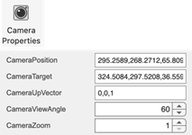
Camera position viewpoint, specified as a three-element vector of the form
[x
y
z]. The camera is oriented along the view axis, which is a straight
line that connects the camera position and the camera target. Changing the
CameraPosition
Camera target, specified as a three-element vector of the form [x y z]. The camera is oriented along the view axis, which is a straight line that connects the camera position and the camera target. For an illustration, see Camera Graphics Terminology.
Upwards direction for the camera, specified as a three-element vector of the form
[x
y
z]. For example, the default orientation of the
z-axis is the up direction ([0 0 1]). For an
illustration, see Camera Graphics Terminology.
Camera zoom level, specified as a positive number.
Type of camera view projection, specified as a "projection" or
"orthographic".
Vertical field of view (FOV) for the perspective camera, specified as a positive
scalar, in degrees. This property applies only when you set the
CameraProjection property to
"perspective".
Viewer background color, specified as an RGB triplet, hexadecimal color code, or a short or long color name. For details on color values, see the Color Value table.
Orientation axes visibility, specified as "on" or
"off", or as a numeric or logical 0
(false) or 1 (true). A value
of "on" is equivalent to true, and
"off" is equivalent to false. Thus, you can use
the value of this property as a logical value.
Gridded axes visibility, specified as "on" or
"off", or as a numeric or logical 0
(false) or 1 (true). A value
of "on" is equivalent to true, and
"off" is equivalent to false. Thus, you can use
the value of this property as a logical value.
Examples
Create a sphere with 2500 faces. This generates a point cloud with approximately 6.25 million points.
numFaces = 2500;
[x,y,z] = sphere(numFaces);
Load an image into the workspace, then map it to the coordinates of the point cloud points.
I = imresize(imread("visionteam1.jpg"),size(x));
color = flipud(im2double(I));
color = reshape(color,[],3);
Create a point cloud object with the location of the sphere and the color from the image.
ptCloud = pointCloud([x(:) y(:) z(:)], Color=color);
Visualize the point cloud, and optionally interact with it using the viewer controls.
pcviewer(ptCloud);

More About
This table shows the valid long color names, their short name and RGB triplet equivalents, and how they appear in MATLAB.
| Color Name | Short Name | RGB Triplet | Appearance |
|---|---|---|---|
"red" | "r" | [1 0 0] |
|
"green" | "g" | [0 1 0] |
|
"blue" | "b" | [0 0 1] |
|
"cyan"
| "c" | [0 1 1] |
|
"magenta" | "m" | [1 0 1] |
|
"yellow" | "y" | [1 1 0] |
|
"black" | "k" | [0 0 0] |
|
"white" | "w" | [1 1 1] |
|
You can expand the viewer toolstrip by clicking the Point Cloud Viewer tab. By default, the toolstrip is collapsed.

| Feature | Viewer Interaction | Description |
|---|---|---|
| Camera Projection |
| Projection style of the camera. |
| Vertical Axis |
| Vertical axis and direction, specified by |
| View Plane |
| Axes plane to display point cloud, specified as |
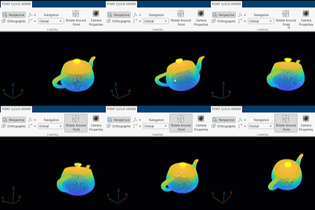
| Navigation |
| View projection used to display the 3-D point cloud, specified as
|
| Rotate Around Point |
| Select any point as the center of rotation. When the Rotate
Around Point is disabled, the center of rotation is the axes
center. The Rotate Around Point mode can only be used
with the
|
| Camera Properties |
| Set camera location and orientation. The CameraViewAngle value applies only for the Perspective camera projection. |
| Color Source |
| Color source from which to render color values for the points. The available options depend on the data in the input point cloud.
|
| Colormap |
| Colormap used to render color. |
| Background Color |
| Viewer background color. |
| Point Size |
| Size of points, in pixels. |
| Magnify Points |
| Magnify the display of points. Enabling this option attenuates the size of the points based on the camera position. If the camera is positioned closer to the points, the points appear bigger than when the camera is far away. Magnify Points applies only for the perspective camera projection and the first person controls. |
| Resolution |
| Controls the number of points rendered in the viewer. This control is only visible if the point cloud data was optimized using an octree conversion. Increasing the resolution provides greater detail but can decrease interaction performance. |
| View Shortcuts |
| View the point cloud viewer keyboard shortcuts. |
| Export Octree |
| Export optimized point cloud. This file can be reused to visualize the point cloud without needing to regenerate the octree conversion. |
Mouse interactions:
| Behavior | Mouse Interaction |
|---|---|
| Rotate | Left-click and drag |
| Pan | Hold Ctrl, then left-click and drag |
| Zoom | Scroll the wheel |
Axes toolbar:
| Behavior | Mouse Interaction or Interaction after Selection |
|---|---|
| Rotate | Left-click and drag |
| Pan | Left-click and drag |
| Zoom buttons | Scroll wheel |
| Default | Return to view from launch of viewer instance |
The point cloud viewer provides orbital and first-person navigation controls. These controls describe the behavior of the observer or first person, represented as the camera, with respect to the object to visualize or orbital, represented as the target.
Orbital— Camera target is fixed. Only the camera position can change.First person— Both the camera position and the target position can change. Enables first-person navigation for the perspective camera projection.
This table lists the mouse interactions for the Orbital and
First person camera controls:
| Interaction | Orbital | First person |
|---|---|---|
| Rotate | Rotate the object around the observer | Observer rotates. (Looks around the scene.) |
| Pan | Pan the object with respect to the observer | Observer moves or "walks" through the scene in the left, right, up, or down directions. |
| Zoom | Zoom object toward or away from observer. (Make the object appear larger or smaller). | Observer moves or "walks" in the forward or backward directions. |
This table shows the orbital keyboard shortcuts:
| Behavior | Keyboard shortcut |
|---|---|
| Rotate by Z-axis | Left and right arrows |
| Rotate by X-axis | Up and down arrows |
| Rotate by Y-axis | Q and E |
This table shows the first-person keyboard shortcuts:
| Behavior | Keyboard Shortcut |
|---|---|
| Move forward | W — Forward S — Backward |
| Move left or right | A — Left D — Right |
| Move up or down | R — Up F — Down |
| Look around the scene (Pitch/Yaw rotation of camera) | Up arrow — Pitch up Down arrow — Pitch down Left arrow — Yaw left Right arrow — Yaw right |
| Roll the scene (Roll rotation of camera) | Q — Clockwise roll E — Counter-clockwise roll |
Version History
Introduced in R2023aLAZ files can now store point clouds in an octree structure optimized for visualization.
To enable this optimization, set the LazVersion name-value argument to
"1.4" of the lasFileWriter (Lidar Toolbox)
object. This optimized storage format for LAZ files is based on the Cloud Optimized Point
Cloud (COPC) format. For details, see the COPC
website.
See Also
Objects
Functions
pcshow|showShape|pcshowpair|plot3|pcwrite|pcread|pcmerge|scatter3|reconstructScene|triangulate|pcdownsample|pcfitplane|pcdenoise|pcregistericp|lasFileWriter(Lidar Toolbox)
External Websites
MATLAB Command
You clicked a link that corresponds to this MATLAB command:
Run the command by entering it in the MATLAB Command Window. Web browsers do not support MATLAB commands.
Select a Web Site
Choose a web site to get translated content where available and see local events and offers. Based on your location, we recommend that you select: .
You can also select a web site from the following list
How to Get Best Site Performance
Select the China site (in Chinese or English) for best site performance. Other MathWorks country sites are not optimized for visits from your location.
Americas
- América Latina (Español)
- Canada (English)
- United States (English)
Europe
- Belgium (English)
- Denmark (English)
- Deutschland (Deutsch)
- España (Español)
- Finland (English)
- France (Français)
- Ireland (English)
- Italia (Italiano)
- Luxembourg (English)
- Netherlands (English)
- Norway (English)
- Österreich (Deutsch)
- Portugal (English)
- Sweden (English)
- Switzerland
- United Kingdom (English)


