mappoint
Planar point vector
Description
A mappoint vector is a container object that holds planar point coordinates and attributes. The points are coupled, such that the size of the x- and y-coordinate arrays are always equal and match the size of any dynamically added attribute arrays. Each entry of a coordinate pair and associated attributes, if any, represents a discrete element in the mappoint vector.
To create a planar point shape for use with a geospatial table, create a mappointshape
object instead.
Creation
Syntax
Description
p = mappoint() constructs an empty mappoint vector,
p, with these default property
settings:
p =

 0x1 mappoint vector with properties:

 Collection properties:
    Geometry: 'point'
    Metadata: [1x1 struct]
 Feature properties:
           X: []
Y: []p = mappoint(
constructs a new mappoint vector and assigns the x,y)X and
Y properties to the numeric array inputs,
x and y.
p = mappoint(
constructs a mappoint vector, then adds dynamic properties to the mappoint
vector using x,y,Name,Value)Name, Value argument
pairs. You can specify several name-value pair arguments in any order as
Name1,Value1,...,NameN,ValueN.
p = mappoint( constructs
a new structArray)mappoint vector, assigning the fields of the structure
array, structArray, as dynamic properties. Field values in
structArray that are not numeric values, string scalar,
string array, character vectors, or cell arrays of numeric values or character
vectors are ignored.
p = mappoint(
constructs a new x,y,structArray)mappoint vector, sets the
X and Y properties equal to the
numeric arrays x and y, and sets
dynamic properties from the field values of
structArray.
Properties
Object Functions
append | Append features to geographic or planar vector |
cat | Concatenate geographic or planar vector |
disp | Display geographic or planar vector |
fieldnames | Return dynamic property names of geographic or planar vector |
isempty | Determine if geographic or planar vector is empty |
isfield | Determine if dynamic property exists in geographic or planar vector |
isprop | Determine if property exists in geographic or planar vector |
length | Return number of elements in geographic or planar vector |
properties | Return property names of geographic or planar vector |
rmfield | Remove dynamic property from geographic or planar vector |
rmprop | Remove property from geographic or planar vector |
size | Return size of geographic or planar vector |
struct | Convert geographic or planar vector to scalar structure |
vertcat | Vertically concatenate geographic or planar vectors |
Examples
Dynamically set the X and Y
property values, and dynamically add Vertex property
Z.
p = mappoint();
p.X = 1:3;
p.Y = 1:3;
p.Z = [10 10 10]
p =

 3x1 mappoint vector with properties:

 Collection properties:
    Geometry: 'point'
    Metadata: [1x1 struct]
 Feature properties:
           X: [1 2 3]
           Y: [1 2 3]
Z: [10 10 10]Define x and y coordinates. Use them
to create a mappoint.
x = [40 50 60];
y = [10, 11, 12];
p = mappoint(x, y)
p =

 3x1 mappoint vector with properties:

 Collection properties:
    Geometry: 'point'
    Metadata: [1x1 struct]
 Feature properties:
           X: [40 50 60]
Y: [10 11 12]x = 41:43;
y = 1:3;
temperature = 61:63;
p = mappoint(x, y, 'Temperature', temperature)p =
3x1 mappoint vector with properties:
Collection properties:
Geometry: 'point'
Metadata: [1x1 struct]
Feature properties:
X: [41 42 43]
Y: [1 2 3]
Temperature: [61 62 63]Read a shapefile into the workspace as a structure array. Then, create a mappoint vector from the structure array.
structArray = shaperead("boston_placenames.shp");
p = mappoint(structArray);Read a shapefile into the workspace as two structure arrays. The first structure array contains the features, and the second structure array contains attributes of the features. Extract the xy-coordinates from the structure array of features.
[structArray,A] = shaperead("boston_placenames.shp");
x = [structArray.X];
y = [structArray.Y];
Create a mappoint vector from the coordinates and the attributes.
p = mappoint(x,y,A);
This example shows how to add a single feature to an empty mappoint vector after construction.
x = 1;
y = 1;
p = mappoint(x, y)
p =

 1x1 mappoint vector with properties:

 Collection properties:
    Geometry: 'point'
    Metadata: [1x1 struct]
 Feature properties:
           X: 1
           Y: 1
Add a dynamic Feature property with a character vector value.
p.FeatureName = 'My Feature'p =
1x1 mappoint vector with properties:
Collection properties:
Geometry: 'point'
Metadata: [1x1 struct]
Feature properties:
X: 1
Y: 1
FeatureName: 'My Feature'This example show how mappoint vectors autoresize all properties lengths to ensure they are equal in size when a new dynamic property is added or an existing property is appended or shortened.
Create a mappoint vector.
x = [1 2];
y = [10 10];
p = mappoint(x,y)
p =

 2x1 mappoint vector with properties:

 Collection properties:
    Geometry: 'point'
    Metadata: [1x1 struct]
 Feature properties:
           X: [1 2]
           Y: [10 10]
Add a dynamic Feature property.
p.FeatureName = {'Feature 1','Feature 2'}p =
2x1 mappoint vector with properties:
Collection properties:
Geometry: 'point'
Metadata: [1x1 struct]
Feature properties:
X: [1 2]
Y: [10 10]
FeatureName: {'Feature 1' 'Feature 2'}Add a numeric dynamic Feature property.
p.ID = [1 2]
p =

 2x1 mappoint vector with properties:

 Collection properties:
       Geometry: 'point'
       Metadata: [1x1 struct]
 Feature properties:
              X: [1 2]
              Y: [10 10]
    FeatureName: {'Feature 1' 'Feature 2'}
ID: [1 2]Add a third feature. All properties are autosized so that all vector lengths match.
p(3).X = 3 p(3).Y = 10
p =
3x1 mappoint vector with properties:
Collection properties:
Geometry: 'point'
Metadata: [1x1 struct]
Feature properties:
X: [1 2 3]
Y: [10 10 10]
FeatureName: {'Feature 1' 'Feature 2' ''}
ID: [1 2 0]Set the values for the ID feature dynamic property with
more values than contained in X or Y.
All properties are expanded to match in size.
p.ID = 1:4
p =
4x1 mappoint vector with properties:
Collection properties:
Geometry: 'point'
Metadata: [1x1 struct]
Feature properties:
X: [1 2 3 0]
Y: [10 10 10 0]
FeatureName: {'Feature 1' 'Feature 2' '' ''}
ID: [1 2 3 4]Set the values for the ID dynamic Feature property with
fewer values than contained in X or Y.
The ID property values expand to match the length of
X and Y.
p.ID = 1:2
p =
4x1 mappoint vector with properties:
Collection properties:
Geometry: 'point'
Metadata: [1x1 struct]
Feature properties:
X: [1 2 3 0]
Y: [10 10 10 0]
FeatureName: {'Feature 1' 'Feature 2' '' ''}
ID: [1 2 0 0]Set the values of either coordinate property (X or
Y) with fewer values. All properties shrink in size
to match the new length.
p.X = 1:2
p =

 2x1 mappoint vector with properties:

 Collection properties:
       Geometry: 'point'
       Metadata: [1x1 struct]
 Feature properties:
              X: [1 2]
              Y: [10 10]
    FeatureName: {'Feature 1' 'Feature 2'}
ID: [1 2]Remove the FeatureName property by setting its value to
[ ].
p.FeatureName = []
p =

 2x1 mappoint vector with properties:

 Collection properties:
    Geometry: 'point'
    Metadata: [1x1 struct]
 Feature properties:
           X: [1 2]
           Y: [10 10]
          ID: [1 2]
Remove all dynamic properties and set the object to empty by setting a coordinate property value to [ ].
p.X = []
 Collection properties:
    Geometry: 'point'
    Metadata: [1x1 struct]
 Feature properties:
           X: []
Y: []This example shows how to include multiple dynamic features during object construction.
point = mappoint([42 44],[10, 11],'Temperature',[63 65], ...
   'TemperatureUnits','Fahrenheit')
point =

 2x1 mappoint vector with properties:

 Collection properties:
       Geometry: 'point'
       Metadata: [1x1 struct]
 Feature properties:
              X: [42 44]
              Y: [10 11]
    Temperature: [63 65]
TemperatureUnits: 'Fahrenheit'This example shows how to construct a mappoint vector using data from a MAT-file containing oceanic depths.
Load data from the seamount MAT-file and construct a
mappoint vector to hold the coordinates.
seamount = load('seamount');
p = mappoint(seamount.x, seamount.y, 'Z', seamount.z);
Create a level list to use to bin the z values and
create a list of color values for each level.
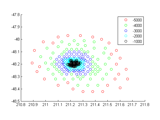
levels = [unique(floor(seamount.z/1000)) * 1000; 0];
colors = {'red','green','blue','cyan','black'};
Add a MinLevel and MaxLevel feature
property to indicate the lowest and highest binned level. Add a dynamic
feature property to indicate the z-coordinate. Add a
dynamic Feature property to indicate a binned level value and a color value
for a given level. Include metadata information from the MAT-file.
for k = 1:length(levels) - 1
   index = levels(k) <= p.Z & p.Z < levels(k+1);
   p(index).MinLevel = levels(k);
   p(index).MaxLevel = levels(k+1) - 1;
   p(index).Color = colors{k};
end
Add metadata information. Metadata is a scalar
structure containing information for the entire set of properties. You can
add any type of data to the structure.
p.Metadata.Caption = seamount.caption;
p.Metadata
ans =

    Caption: [1x229 char]
Display the point data as a 2-D plot.
figure
minLevels = unique(p.MinLevel);
for k=1:length(minLevels)
  index = p.MinLevel == minLevels(k);
  mapshow(p(index).X, p(index).Y, ...
   'MarkerEdgeColor', p(find(index,1)).Color, ...
   'Marker', 'o', ...
   'DisplayType', 'point')
end
legend(num2str(minLevels'))
Display the point data as a 3-D scatter plot.
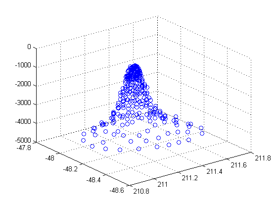
figure
scatter3(p.X, p.Y, p.Z)
Create a mappoint vector from a structure array. Then, add features and metadata to the mappoint vector.
Read a shapefile into the workspace as a structure array.
filename = "boston_placenames.shp";
structArray = shaperead(filename);
Create a default mappoint vector. Then, add features and metadata to the mappoint vector by updating its properties.
p = mappoint();
p.X = [structArray.X];
p.Y = [structArray.Y];
p.Name = {structArray.NAME};
Alternatively, you can create a mappoint vector by passing the structure array to the mappoint function.
p = mappoint(structArray);
Add a Filename field to the Metadata structure.
p.Metadata.Filename = filename;
This example show how to add a feature to the mappoint vector using linear indexing.
Append Paderborn, Germany to the vector of world cities.
p = mappoint(shaperead('worldcities.shp'));
x = 51.715254;
y = 8.75213;
p = append(p, x, y, 'Name', 'Paderborn');
p(end)
ans =

 1x1 mappoint vector with properties:

 Collection properties:
    Geometry: 'point'
    Metadata: [1x1 struct]
 Feature properties:
           X: 51.7153
           Y: 8.7521
        Name: 'Paderborn'
You can also add a point to the end of the mappoint vector using linear indexing. Add Arlington, Virginia to the end of the vector.
p(end+1).X = 38.880043;
p(end).Y = -77.196676;
p(end).Name = 'Arlington';
p(end-1:end)
ans =
2x1 mappoint vector with properties:
Collection properties:
Geometry: 'point'
Metadata: [1x1 struct]
Feature properties:
X: [51.7153 38.8800]
Y: [8.7521 -77.1967]
Name: {'Paderborn' 'Arlington'}
% Plot the points
figure
mapshow(p.X, p.Y, 'DisplayType', 'point')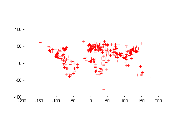
Read a shapefile into the workspace as a structure array. Then, create a mappoint vector from the structure array.
structArray = shaperead("tsunamis.shp");
p = mappoint(structArray);
Sort the dynamic properties so they are in alphabetical order.
fn = fieldnames(p);
p = p(:,sort(fn));
Create a new mappoint vector that contains these dynamic properties: 'Year', 'Month', 'Day', 'Hour', and 'Minute'.
dp = {'Year','Month','Day','Hour','Minute'};
p2 = p(:,dp);This example demonstrates that input arguments
x and y can be either row or
column vectors.
If you typically store x- and
y-coordinate values in an n-by-2 or
2-by-m array, you can assign a mappoint object to
these numeric values. If the values are stored in an
n-by-2 array, then the X property
values are assigned to the first column and the Y
property values are assigned to the second column.
x = 1:10;
y = 21:30;
pts = [x' y'];
p = mappoint;
p(1:length(pts)) = pts
p =

 10x1 mappoint vector with properties:

 Collection properties:
    Geometry: 'point'
    Metadata: [1x1 struct]
 Feature properties:
           X: [1 2 3 4 5 6 7 8 9 10]
           Y: [21 22 23 24 25 26 27 28 29 30]
If the values are stored in a 2-by-m array, then the
X property values are assigned to the first row and
the Y property values are assigned to the second
row.
pts = [x; y];
p(1:length(pts)) = pts
p =

 10x1 mappoint vector with properties:

 Collection properties:
    Geometry: 'point'
    Metadata: [1x1 struct]
 Feature properties:
           X: [1 2 3 4 5 6 7 8 9 10]
           Y: [21 22 23 24 25 26 27 28 29 30]
Observe that in both cases, X and Y
are stored as row vectors.
More About
Tips
If
X,Y, or a dynamic property is set with more values than features in the mappoint vector, then all other properties expand in size using 0 for numeric values and an empty character vector ('') for cell values.If a dynamic property is set with fewer values than the number of features, then this dynamic property expands to match the size of the other properties, by inserting a 0 if the value is numeric or an empty character vector (
''), if the value is a cell array.If the
XorYproperty of the mappoint vector is set with fewer values than contained in the object, then all other properties shrink in size.If either
XorYis set to [ ], then both coordinate properties are set to [ ] and all dynamic properties are removed.If a dynamic property is set to [ ], then it is removed from the object.
The mappoint vector can be indexed like any MATLAB® vector. You can access any element of the vector to obtain a specific feature. The following examples demonstrate this behavior:
Version History
Introduced in R2012a